Saturday 16 December 2006

Mt Wellington - 16th Dec 2006

Tinderbox and Bruny Island beyond South Wellington - 16 Dec 2006
Needed one last walk before going back to work, so I just scooted on over to Mt Wellington yesterday and walked to the summit. Nice day, moderate temperature, light breeze. The views were moderately good, including the smoke to the east from the Kellevie fires, and a vague impression of smoke in the northeast from the St Marys-area fires. Especially good yesterday was the view south to Bruny Island etc.
Wildflowers growing in rocksThe wildflowers are adding some colour to the normally somewhat dull vegetation across the summit plateau. Scoparia (Richea scoparia), Baeckea (Baeckea gunniana) and Creeping Tea-tree (Leptospermum rupestre) are all in evidence at various points. Further down the mountain various other plants are also adding colour, including the Waratah (Telopea truncata) and Golden Rosemary (Oxylobium ellipticum).
Stonework on Zig-Zag track (First 'Zag')
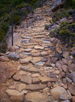
Interesting on these tracks are the efforts of the track builders, whom I believe have mainly been Green Corps volunteers. Some very good stonework in particular has vastly improved some sections of the track. The Zig-Zag track received a lot of work in recent years. Of more recent note is work on some previously eroded mid to upper sections of the Icehouse Track. The people who have done this work are to be congratulated.

South Cape Bay moods

Just to provide some contrasts at South Cape Bay.


After a storm - the beach was covered in waist-deep foam, and incoming waves (very powerful on the day) would sweep up the beach to the dunes beneath the layer of foam. Spectacular to see. This photo vaguely illustrates what this was like.


Knee to waist-deep foam on South Cape Bay, mid 2005, following storm


The bay itself was a complete maelstrom, with the most enormous waves breaking well beyond the outer end of Lion Rock. It was rough enough when we were there, it must have been an amazing sight at the height of the storm, which occurred during the preceding 24 hours.


South Cape Bay following storm, mid-2005
South East Cape following storm, mid-2005


These photos show a much more benign and restful bay at sunset...


South Cape from South Cape Bay, 21 Apr 2005
Lion Rock, South Cape Bay, 21 Apr 2005


And then at sunrise.


Lion Rock, South Cape Bay, 22 Apr 2005

Wednesday 13 December 2006

South Cape Bay - 13 Dec 2006

Lion Rock, South Cape Bay, Tasmania - 2003Not having done enough exercise lately ;-), and the weather forecast being pretty good (and work looming next week!), I went off to South Cape Bay today. Quite an easy walk, but enjoyable, and the beach is attractive and interesting. The road was being graded today, and is certainly in better nick than previously.
South Cape Bay - 2006The beach appears to have a lot more pebbles and exposed rock than the last time I was there. Don't know if the weather has been particularly rough, but some of the sand has been washed South Cape Bay - 2006away at least for now. Made for more interesting photos though. I went there a while back after a storm, and the whole bay was a seething mass of foam. The waves moved around under the foam. I got some photos, but they just don't convey the amazing sight that day. These photos are from today.
Burnt vegetation, Blowhole Valley, Tasmania - 2006Blowhole Valley, which burnt some time ago, is looking better although not great yet. They've done a fair bit of work on the track, restoring some boardwalks, some stonework here and there, and some other work. In particular, the boardwalks are now above the waterline in a few places where previously they were submerged. Makes for a very easy walk. I noted that someone has cleaned up the beach, and there's a pile of fishing detritus where the steps go down to the beach.
Crater-lake - Blowhole Valley, Tasmania - 2006In 2004, when the area was burnt, they used explosives to make holes to collect water as a safety precaution. These were very unsightly, and spread an "explosion" of black mud across the landscape. A couple of them caused the track to flood. No doubt they were useful at the time. The minister assured us that it was necessary, and that the holes would refill themselves (?!). Anyway, he was wrong, the holes are still there. Accident-prone Ken was wrong about a few things in his time, and is no longer with us in an official capacity!
South East Cape, Tasmania - 2006South East Cape is the most southerly point of mainland Tasmania, and should probably be recognised more clearly as Australia's most southern point. Trouble has been, it's virtually inaccessible. However, I have heard a rumour that some naughty person has cut a track through the infamous scrub. I'll investigate further!

Tuesday 12 December 2006

White Timber Mountain - 12 Dec 2006

Waratah in the forest along the White Timber Trail, Wellington Range, TasmaniaThis was a walk I hadn't done before. White Timber Mountain is behind Crabtree in the Wellington Range, and the walk is described in David Leaman's book Walk Into History In Southern Tasmania, (Leaman Geophysics, 1999). Quite a good walk, although mostly on 4WD tracks. The forest is very attractive, with waratah (left) and other flowers making a nice display.
The 'pinnacle' of White Timber MountainThe walk starts at the intersection of Crabtree Rd and Mitchell Rd. Don't expect to do the loop walk described in Leaman's book - the Stony Point Trail, which is the return route described, is closed where it crosses private land. I'm assuming this is legal, as the signs had Tas Fire Service and Forestry Tas logos on them. A steep climb up Mitchells Rd/Jeffreys Track brings you to the White Timber Trail. An easy walk along the range on this trail, and then a short climb to the high point of this track. Here there are some tattered bits of flagging and a couple of cairns beside the track, indicating the right turn onto a rough pad through the scrub and up the ridge to the summit (956m). The summit is basically a medium-sized boulder amongst the trees. Views only moderate due to the trees, but I did get a good view of Mt Picton covered in snow.
Tiger Snake on track to White Timber MountainDecent-sized snake (Tiger I think, but I'll stand corrected) appears to live on the track on the final climb up the mountain. S/He was quite lazy, but I think I annoyed him/her a little getting the photos. S/He was there on both ascent and descent. Didn't see any others though.

Monday 11 December 2006

Weld Valley Touring Route

It looked like a good opportunity. Forestry Tasmania were touting the opening of a touring route in the Weld. There's also a pdf. Unfortunately, it doesn't look like you can take yourself around the route, but have to get on an Evan's Coaches bus and be driven around. Comfortable perhaps, and no doubt justified as a safety matter in an area where forestry operations are underway. However, I'd sort of hoped I could just hop in the car and drive around having a look at what's really going on out there. Anyway, I've asked Forestry whether this is possible, and await the answer, without much hope, nor expectation of a rapid response.

There was a letter in The Mercury today from Rob Blakers (photographer), in which he suggests that approximately 1/3 of the Weld forests are available for harvesting. This media release recently from Forestry Tasmania indicates that only 12.5% is available, and only 2% will be harvested over the next 8 years. It will be interesting to watch the debate that now ensues. The government have been caught out fudging the difference between buttongrass moorland and "old-growth forest" in the past and there have been various disagreements about the meaning of the numbers. This Google starts to give a flavour.

Sunday 10 December 2006

Mt Field West - 9 Dec 2006

Mt Field West (the small distant ramp on the ridge to the left) from K-Col. Also Naturaliste Pk (L), The Watcher (R), Wyld's Craig (Centre), 9 Dec 2006 - 190KB It was a pretty warm day on Saturday (~32deg+ in Hobart, more at Bushy Park), so I went to Mt Field West! (Map here) Pretty warm there too! Great walk though, as long as you don't dwell too much on the view into the Florentine Valley.

If you haven't been there, the walk starts at Lake Dobson in the Mt Field National Park. A moderate climb brings you to the ski-fields, and a very pleasant walk across duckboarding leads towards Tarn Shelf. The track to Mt Field West branches off just before that, climbs up and over the Rodway Range, mainly on boulders, and down to K-Col. (Google Maps makes it very clear why it's called K-Col.) From there it climbs steadily along an open ridge and then across a lovely alpine plateau before a final short climb up the ramp which is Mt Field West's summit. The views are extensive from the peak, as well as from most of the walk.

Northerly view up the Florentine Valley from Mt Field West, 9 Dec 2006 - 127KBIf it wasn't for the highly visible forestry operations, this walk would be close to perfect. I recall some years ago being able to hear the machinery and the falling trees in a Florentine coupe below the peak. Yesterday it seemed quiet, with just a small plane flying past and north along the valley. I wondered who was looking for what in the Florentine Valley. It's the subject of some controversy at present. This text from a Wilderness Society media release in March this year:
Westerly view across the Florentine Valley from Mt Field West, 9 Dec 2006 - 109KB
  • However, the Government’s literature about the Howard-Lennon agreement of last May admits that the protected areas in the Styx and Florentine contain ‘4730 hectares of old-growth eucalypt against a target of 18,700 hectares’. (The Tasmanian Community Forest Agreement, Fact Sheet No. 3) “The Government admits that it failed to meet its promise by nearly 14,000 hectares of oldgrowth,” said Mr Law. “The giant trees in these forests are now being destroyed.”

And there's more information here.


Richea scoparia, with Florentine Peak behind, 9 Dec 2006 - 283KBAnd on a more positive note, the Scoparia was looking particularly attractive on the ridge up to Naturalist Peak. Hopefully got a few good shots on the film camera. It would definitely be best at sunrise or sunset, but was pretty good anyway.

Friday 8 December 2006

Picton River Valley

I managed to get this view of the Picton Valley from Google Maps. (The enlargement is clearer). It's out-of-date, but I'm unsure how much. The recent coupe high up on the Picton foothills doesn't seem to be evident, and the ones which stand out most clearly have grown over somewhat now.
That's Mt Picton on the west (left of the picture) with it's lakes showing clearly. Hartz Peak is at the bottom, off to the east a little, and the Picton River flows down the middle between the various forestry coupes. The somewhat infamous Farmhouse Creek meets the Picton at approximately where the most southerly forestry work can be seen. This forestry work effectively splits the Hartz Mountains from the rest of the World Heritage Area. It would be tempting to assume that the cutting at Farmhouse Creek years ago was to make sure the furthest possible incursion had been made at an early stage. Interesting chronology here.
There's some more information at the Tasmanian Times and The Wilderness Society about Google Earth views of forestry coupes. The maps of forestry coupes are available at the Forestry Tasmania site, but they're in a great big long list, and you really need to look carefully at them to work out where they are. Being able to decipher the map references helps.

Thursday 7 December 2006

Mt Wellington - 6 & 7 Dec 2006

I walked on Mt Wellington on Wednesday and Thursday. The wildflowers are particularly attractive along the Panorama Track, where they brighten up the carpet of low shrubs. The Waratah is out along the Pinnacle Track. Talking to a group of ladies walking here, they felt that the best of the Waratah was gone now. I should note that at the Hartz Mountains, the Waratah is just coming out, maybe it's been colder there.

There's an interesting thread on aus.bushwalking about solar cells for charging "toys" along the track. Given that lots of people cary all sorts of useful things with them in the bush, some sort of universal charger would be pretty useful I think. I carry a pocket pc for all sorts of reasons, including as a phone, but it chews through the battery power, and doesn't take AAA batteries. A solar charger would help. Among other things, I take notes on it. This would be especially useful when I'm on a multi-day walk, but the power just doesn't last long enough.

On a related note, it's surprising how mobile phone reception varies when walking on Mt Wellington. Don't expect to always have full reception, even when very high up. My phone was struggling near the summit the other day. I've just tried the Telstra website for maps of coverage, but at this point it's too well hidden for me to find it. I'll try again!

Wednesday 6 December 2006

Hartz Peak - 5 Dec 2006

Yesterday I walked up Hartz Peak. Nice day, but a strong cold breeze was blowing straight out of the west. Good views, with Frenchmans visible to the northwest. Especially clear is the latest forestry coup on the western side of the Picton valley, quite high up on the Mt Picton foothills. (As seen in the rather poor phone-camera image) The view back towards Hartz Peak from Mt Picton is even worse of course, with a lot of cutting having been undertaken on the "hidden" western slope of the Hartz Mountains, the eastern side of the Picton valley. I must have a look at it on Google maps. Just not sure how up to date the pictures of southern Tasmania are.
On a happier note, the track work at the Hartz is very welcome, and each time I walk there it seems a new bit of work has been completed. The stonework high up is terrific, and I see they've also added some little orange arrows to assist when there's snow on the ground (as there was a week ago).
I also see that the building work is proceeding at the end of the road, where they are building a shelter and toilet. Some other improvement work is also going on, and is detailed in the action plan.