Sunday 31 August 2008

Organ Pipes Walk, Mt Wellington - 30th August 2008

Forest along Hunters Track, Mt Wellington - 30th August 2008Yesterday I went for a walk on Mt Wellington for a while. It was supposed to be a warm day, but it remained overcast with a chilly breeze on the mountain slopes. I discovered part-way around that I seemed to be doing the "Organ Pipes Walk" which is one of the 60 Great Short Walks. There didn't seem to be very many people around. This walk sets out from The Springs, climbs beneath the Organ Pipes, then descends to Junction Cabin via Hunters Track. The last bit is the gentle climb back to The Springs along the Lenah Valley Track. This is a good walk on a day when you don't want to climb to the summit. The forest below the chalet along Hunters Track and through along part of the lenah Valley Track shows the effects of fire a few years ago. As I recall, this was a deliberately lit blaze that started behind Glenorchy and climbed the mountain, cutting quite a swathe through the nearly 40 years of regrowth since it was devastated by the 1967 fires. It wasn't as devastating as the earlier fire though, and the forest is recovering. The light yesterday wasn't very inspiring for photographs, but the walk was welcome exercise after a week at work.

Junction Cabin, Mt Wellington - 30th August 2008Junction Cabin is a cosy place on a wet day as long as someone has lit a fire. The area around here has been used for camping as well at times, and I have heard people say it was the first place they took their young children for an overnight walk. The grassy areas around the hut are a little slopy, but you could certainly put a tent up. The hut has a water tank and table/benches inside. There is often a supply of firewood left here by the rangers/council.


View Larger Map

Thursday 28 August 2008

Remarkable Cave

The Remarkable Cave area, taken from the track towards Maingon Blowhole and Mount Brown - 19th August 2008I tried to find some good information about Remarkable Cave online, as the bits of info from brochures and signs is fairly sketchy. Having failed to find much, I read my books. There I found some good info. I'll put this up for now, but I need to read more, get some better pictures, now I know what I'm looking for, and also get inside the cave.

Most of the solid information I have found about Remarkable Cave comes from the work of David Leaman. This comes from his books The Rock Which Makes Tasmania (Review here) and Walk Into History In Southern Tasmania.

View through Remarkable Cave - 19th August 2008The cave was originally called “Remarkable” because of the way there appeared to be a map of Tasmania if you stood inside and looked through the cave at the right angle. You can see this clearly as you stand on the viewing platform.

Now, to make the cave more interesting, it has two entrances from the sea-end. Two separate caves have joined up. I recall walking through the cave many years ago. I think at that time access to the floor of the cave was less restricted. The viewing platform these days tends to discourage venturing further. I didn’t clamber down, as the sea was washing into the cave rear, and there was little point. However, when you can walk through the cave it is very interesting. I’m trying to find photos from all those years ago.

David Leaman’s view is that the cave is quite unremarkable (“run-of-the-mill”). He’s speaking as a geologist. His view is that the intrusion of the dolerite, the rocks it intruded, and the effects that intrusion has, is what makes the area remarkable. I suppose most tourists would disagree, but the rocks are very interesting. They can be seen clearly from a number of vantage points. I think there is also much to be seen inside the cave, so I’m keen to return when the tide is low enough.

In summary, Leaman says the following:

Triassic sandstones overlie Jurassic dolerite, note the dolerite is highly fractured, which has assisted the sea in forming the sea caves - 19th August 2008Most of the rocks here are Triassic sandstones. These were intruded by Jurassic dolerite. The intrusion can be seen clearly around Remarkable Cave. The top of the intrusion and its contact with the sandstone can be seen in the cliffs and shore platforms around the area.

Intensely folded and metamorphosed Triassic sandstones in cliffs directly south of the Remarkable Cave carpark - 19th August 2008The sandstone in contact with the dolerite as it intruded displays “exquisite and intense folding”. The easiest place to see this is from the lookout below the car-park, looking south to the cliff below. Leaman says that if you can walk through the cave, then there is more folding to be inspected. Dolerite of course forms many major nearby features; Mt Brown, Cape Raoul, Cape Pillar etc

Shore platforms near Remarkable Cave (looking east towards Mt Brown) showing contact between sandstone and dolerite very clearly - 19th August 2008The question is whether the folding occurred at the time of the intrusion, or when the rock was laid down. There is no firm answer. A previous doctoral thesis (Powell, 1967 - Studies in the geometry of folding and its mechanical interpretation) had suggested that the folding was caused by the heating of the rock with hot liquids and gasses related to the intrusion. Leaman thinks this is unlikely, and that the sandstones were folded soon after they were deposited, when they were poorly compacted. They were then overlaid by more sandstones, and then later intruded by the dolerite. The dolerite intrusion has altered (metamorphosed) the sandstone by heat. Leaman notes that the distorted sandstones are also intruded and cut by the dolerite suggesting that the folding existed before the intrusion of the dolerite.

Interesting place anyway.

Sunday 24 August 2008

Freycinet Fungi

Didn't spend a lot of time looking for fungi, but here are three examples.


Freycinet Peninsula - 21st-23rd August 2008

Hazards from Cooks Corner at sunset - 22nd August 2008Had a very nice winter walk down the Freycinet Peninsula for three days. Many of the creeks were flowing, making it a somewhat different experience to my last visit, and to the usual situation. Thursday, and Thursday night, were cold and snowy around Hobart I gather. On the peninsula there was some rain on Thursday night but apart from that it was fine although cool. I even had a coolish dip in the sea on Friday afternoon, then let the sun and gentle breeze dry me off. I walked down to Cooks Beach via Hazards Beach to find myself the only camper for two nights. In fact, I didn't see another person south of the Isthmus Track at all.

Snow on Mt Freycinet summit - 22nd August 2008Friday was mainly spent climbing Mt Freycinet. The actual Peninsula Circuit walk involves walking south along the west coast to Cooks Beach, and then returning via the heights of Mt Freycinet's flanks and Mt Graham. I did this last time, but this time I avoided the carry of a full pack up the nearly 600m climb to Mt Graham, and made Mt Freycinet a morning's walk with just a daypack. Mt Freycinet is the high point of the area at 620m. Snow was forecast down to 500m the night before I think, and, true, I found snow on top of Mt Freycinet. I presume this is not very common, although I did read the warning in the walk registration shelter that walkers should remember to take warm clothing as snow did fall there at times. I suppose it's unusual to think of snow on Tasmania's east coast in such a maritime location. I have to admit that the total area of snow I found still protected from the sun by rock shadows was probably less than a square metre. Flowing water was available in several creeks along the track to Mt Freycinet inlcuding quite high up.


Hazards and Wineglass Bay from Mt Freycinet - 22nd August 2008The views from Mt Freycinet and Mt Graham of the peninsula, Wineglass Bay, The Hazards and Schouten Island are very good. Of course you can also see quite a lot of Tasmania's east coast. Mt Freycinet is the mountain the runners have to climb when the Three Peaks Race visits Coles Bay, and I have to say I admire people who can run up and down this peak, from Coles Bay, especially if they have to do it in the dark. In the afternoon I visited Bryans Beach for a short while, which looks south to Schouten Island. Bryans, which faces southwest, is often rougher than Cooks Beach, which faces east and northeast. However, when I visited it was very calm. I cut short the visit in order to get back to Cooks for sunset on the Hazards, which turned out to be well worthwhile.


Three Southern Right Whales (Eubalaena australis) in Wineglass Bay - 23rd August 2008Walked out by the low level route on Saturday, stopping to watch Southern Right Whales (Eubalaena australis) (See here for the best info on Right Whales that I can find so far) lazing around in Wineglass Bay. It was hard to tell how many there were from the shore, but inspection of the photos on return home revealed three in at least one shot - I suspect this is a mother, a smallish calf and maybe another older calf. I don't think father-whales hang around with the family, but I must read up on them a bit more. They were attracting attention from walkers, but it was interesting to see people gawping about the bay without noticing these very large creatures moving about only a couple of hundred metres away. I recall sitting in Wineglass Bay, on the granite near the track-end, on a Geology excursion some few years ago. The teacher was banging on about pink and grey granites while behind him a whale played in the bay. In the end he had to sit down and shut up until the whale got tired and moved on, when the class were able to direct some attention to how The Hazards formed.


View Larger Map

Wednesday 20 August 2008

Crescent Bay and Mount Brown - 19th August 2008

Arthurs Peak, Cape Pillar and Tasman island from Crescent Bay - 19th August 2008Having been inspired by Peter to go and do this walk again yesterday, after probably a 20-year break, I found I thoroughly enjoyed it. The distances aren't too great nor the climbs too onerous, and there's lots to look at. I hope Phil isn't reading, as he wanted to do this walk a while ago. I did try to ring him. The walk starts at the Remarkable Cave carpark, and winds across old dunes to the Maingon Blowhole, Mount Brown and Crescent Bay. Remarkable Cave has enough interesting features to score a blog entry of its own I think.

Maingon Blowhole - 19th August 2008The Maingon Blowhole has a serious warning sign ("anything that happens is your own fault" -type of sign) just before you get to it, and I think it's justified. It's a narrow slit in the earth, which drops some rather large distance into a heaving sliver of white water. The edges are sloping, crumbly, grassy and slippery, and a fall would undoubtedly be fatal. Well worth a look! I'm not sure if it actually "blows" in a heavy sea. I haven't been there before, having done this walk from the opposite direction in years past. Just beyond here, the rocky shore could be explored at length if time and sea conditions allowed.


Dauntless Point from Mount Borwn clifftop - 19th August 2008The track then passes Mount Brown, a large dolerite protuberance, and a rough cairned track heads steeply up the hill. The views from the top are great; Crescent Bay, Port Arthur, Cape Pillar, Tasman Island and Cape Raoul make a dramatic 360 degree vista. Particularly spectacular is the view from the high western end of the hilltop, which is basically a 170m cliff. There are great views from here down onto Dauntless Point, which has its own dramatic and interestingly fractured cliff. I can say the dolerite on this headland is particularly gritty and sharp, having personally tested it with hands and knees when a rock shifted beneath me.


Crescent Bay - 19th August 2008Descending Mount Brown, the track then heads down to Crescent Bay, which is a beautiful beach with high dunes. At the far end of Crescent Bay is Standup Point, which has its own blowholes. I only made it to the first one (apparently smaller) before my turn-around time arrived, enabling me to be taxi in Hobart later in the afternoon. Apparently these blowholes do blow spectacularly in heavy seas when I assume they become more difficult and/or dangerous to access. The amount of time that could be spent taking in the views and investigating the various sights along the way took me by surprise, and I found I ran out of time, which probably requires a return trip (Phil).


Yellow-Tailed Black Cockatoo, Crescent Bay - 19th August 2008Hooded Plovers, Crescent Bay - 19th August 2008I found three Hooded Plovers on the beach, and a gaggle of angry and noisy Yellow-Tailed Black Cockatoos in the dunes. None of them were very pleased to see me. I'm assuming the plover with the blotchy head markings is actually a juvenile, perhaps hatched last spring.

Monday 18 August 2008

Mt Wellington - 18th August 2008

View of Big Bend, Mt Arthur and Lost World from high on Pinnacle Rd, Mt Wellington - 18th August 2008The good forecast today and the good snow cover suggested this might be the best day to get into the snow. Mt Wellington was the easiest target, although I met Roger at the Chalet, and he was planning a walk to somewhere like Nevada Peak or Adamsons for tomorrow. Adamsons certainly has a very solid cover of snow, and makes a fine sight from Huonville when the sun catches it right now. However, Mt Wellington was pretty good.

Eucalypts weighed down by snow, one had broken off; Mt Wellington - 18th August 2008I walked up the ZigZag Track, and had some trouble on sections of it. The snow was mostly quite firm, but the usefully hard crust also made it difficult on the steepest section. The ZigZag isn't too bad, but there are sections where if you went sideways off it you'd slide a fair way before fetching up against a rock or a tree.


Snow plough operating at Mt Wellington summit - 18th August 2008I hoped to have the summit to myself, but the snow ploughing crew were there. The little snow plough is quite interesting to watch, although they did rather shatter the silence. The design of the actual ploughing implement is intriguing, but obviously effective. I asked them to keep the road closed for a while so I could walk down it without having to look out for cars. They managed to do so.


Summit shelter hut and pinnacle in snow, Mt Wellington - 18th August 2008The return was easier, as I avoided the ZigZag and used the road and other tracks to return easily around the north and east sides of the mountain. A couple of others who had climbed the ZigZag decided this was the best policy too. I think crampons would have helped in a descent (or an ascent for that matter). The snow is really quite deep in places, and reminds me of years past. I don't think I've seen this much snow on Mt Wellington for a long time. I recall a good fall when my eldest was about 12 months old (1994), and then some really deep snow in the 1970s, when the road was cut between 2-3m banks of snow. With more snow forecast, it looks like it will continue for a while. The amount of snow that is there now will take a while to melt even without further falls.


Northerly view to Mt Hull, Mt Faulkner, Mt Dromedary and Platform Peak from Pinnacle Rd, Mt Wellington - 18th August 2008A pair of Wedge-Tailed Eagles passed across the front of the mountain as I walked down. I was accompanied at this point by Ray, who told me that there are two pairs of eagles who frequent the mountain at present. The only photo I could manage at the distance was unfortunately not worth the the inconvenience I caused the electrons with which it was recorded. I will refrain from troubling any more electrons, or your eyeballs. This is the northerly view to Mt Hull, Mt Faulkner, Mt Dromedary and Platform Peak, upon the last two of which it appeared to be precipitating in direct contravention of the BoM's instructions for the day!

Sunday 17 August 2008

Chimney Pot Hill - 16th August 2008

Mt Wellington from Chimney Pot Hill - 16th August 2008There are plenty of tracks at Ridgeway, mostly well formed and marked. They aren't all on any single one of the available maps however. Parking at Halls Saddle is a good point to start an easy walk up Chimney Pot Hill. See the map for info. This hill provides a great view of Mt Wellington. At the top, next to the Telstra installation, there's an old rock hut, which looks like it was probably a store-hut for some original hilltop installation in years past. The Mt Wellington view is superb from here and well worth the climb.

Forest at Ridgeway - 16th August 2008Leaving the top, there are a range of options, and you can explore the tracks as time and your desire for hill climbs dictate. On days with dodgy weather, these tracks offer some good views without quite the altitude of the upper slopes of Mt Wellington. The forest is very open and attractive, and there are good views through the trees at many points.


As an aside, the nearby native plant nursery (Plants of Tasmania Nursery, 65 Hall St Ridgeway) has a great range of Tasmanian plants often seen only in their natural habitat, and is worth a look.


View Larger Map

Saturday 16 August 2008

Fungi from the South Cape Bay Track

Fungi (hygrocybe?) on South Coast Track - 15th August 2008I think this one is a Hygrocybe, and very similar to one I found on a different part of the track in May 2007.

South Cape Bay - 15th August 2008

South Cape Bay - 15th August 2008With the Tasmanian winter continuing, it was time for a good sea-level walk. South Cape Bay would have been wilder, with bigger surf, a day or two before, but transport issues led to Friday working out. Despite having been recently, I headed off, hoping the weather was moderate. This is a really good walk, and I do enjoy the wild coast once you get out to the bay. The weather wasn't promising in the Huon on Friday morning, but as it turned out, I got quite a lot of sun mixed in with some drizzle, a solid cold breeze and the occasional squall. All in all, it was a good day's walk.

Foam on beach in front of Lion Rock, South Cape Bay - 15th August 2008The beach had some foam sitting on it, so the surf has been quite wild, but nothing like it was on a visit in 2005 following a full storm.


Plastic fragments from fishing boat junk on South Cape Bay Beach - 15th August 2008It's interesting to see the high-tide mark of pulverised plastic fragments along this beach. Most of the junk they came from appears to come from fishing boats. There's quite a collection of fishing junk along the track as it climbs onto the cliffs.


Hooded Plover, Thinornis rubricollis, South Cape Bay - 15th August 2008There was a single Hooded Plover (Thinornis rubricollis) wandering the beach yesterday. You normally see two together here, if you see them at all. They are always wary of people, but you can often get close to them by just sitting and waiting for them to wander closer. This one was very wary, and I didn't want to upset him. Obviously for photographing birds this size, I need a new camera with a much bigger lens! It was very difficult to capture a decent shot of this little bird, with my camera and lens, especially given the speed at which he darted about the beach. This one will do, but I'm not happy with it.


Rainbow and South East Cape from South Cape Bay - 15th August 2008All in all it was quite a nice day, if persistently chilly. I'll finish with this shot of a rainbow and South East Cape.


View Larger Map

Thursday 14 August 2008

South Arm - 13th August 2008

Surf on Hope Beach, with hills (Underwoods, Farewell?) above the channel covered in snow in the distance - 13th August 2008The Hobart and mountain weather yesterday was pretty ordinary, so I went to South Arm. Road closures early in the day kept some people from travelling, and gave my kids a good excuse not to go to school. The road was open from mid-morning though. Lazy sods! On South Arm, the sun was out for much of the time, and it was even quite warm at times. I walked along Hope Beach from Goats Bluff. On the return trip I went through the dunes to South Arm Road and wandered along the edge of Ralphs Bay. Having returned to the car, I went down to Calverts Beach and had another walk along there. Given the state of the weather elsewhere, it was quite pleasant. I have to wonder what they all do for water on South Arm - while it was raining everywhere else, they were getting very little.

Surf on Hope Beach - 14th August 2008The surf was impressively large yesterday, with the waves breaking along much of the length of the beach all at once.


Shaw's Cowfish, (Aracana aurita) Hope Beach - 14th August 2008This fish had been thrown up by the waves. As I was looking it up in the fish book, the kids told me it was a Cowfish. They know, apparently, because they've all been to the Woodbridge Marine Discovery Centre. See, an education is useful! I was thinking some sort of Toadfish, but the kids were right, and they're related in the order Tetraodontiformidae. Like toadfish, these are also poisonous. My book suggests it's a female Shaw's Cowfish, Aracana aurita.


Hope Beach, showing slope - July 2007Hope Beach cops a pounding from the swells that come into Storm Bay. The sand on the beach is always quite soft and hard to walk on. The beach also slopes quite steeply along much of its length. This photo taken last year shows this. At times, and in places, the waves wash right up to the dunes on a steep slope, or create a large berm hard by the dunes, against which they wash at high tide. Not a good beach for a casual swim, and you need to be careful in places. The whole of the South Arm Neck is apparently the result of a the original 200-metre deep Derwent River gorge being gradually filled in with clay, sand and gravel. (Ref. David Leaman 1999, Walk Into History In Southern Tasmania)


Garbage grows on trees, Ralphs Bay - 14th August 2008On the inside of the neck is quiet Ralphs Bay. This place seems to be the Hobart garbage filter, where the bottles and plastic bags end up. This tree was liberally festooned with crap.


Eagle Ray, Ralphs Bay - 14th August 2008This Eagle Ray, Myliobatis australis, was dead on the beach. Probably ate some of the garbage!


Calverts Beach and Goats Bluff, Betsey Island in background - 14th August 2008Calverts Beach is on the eastern side of Goats Bluff, and provided some spectacular viewing in the large surf yesterday. Behind this beach is Calverts Lagoon, considered to be an important wetland area. The lagoon does appear to be quite dry when viewed from the road at present. Information about it can be found by searching at this site.

Tuesday 12 August 2008

Cape Hauy - 11th August 2008

Cape Hauy and surrounds as viewed from the Pirates Bay Lookout - 11th August 2008I first went to Cape Hauy (
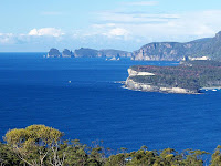
Walk Description here.) in 1987, and I'm pretty sure it was the 16th July. I only remember that because I was taken (even surprised and alarmed!) with how warm and sunny Tasmania could be in the middle of winter when you were toiling up a steep hill. Anyway, the sun didn't disappoint yesterday, and came out warm and strong whenever I needed to walk up a hill. To get a clear understanding of the layout of the Cape and surrounds, it's worth stopping at the Pirates Bay Lookout, just along the old highway which turns off before the new highway drops steeply to Eaglehawk Neck. From here you can clearly see the Cape, Candlestick, Totem Pole and Lanterns, a view which you don't get once you are on the Cape.

Cape Pillar from the Cape Hauy Track - 11th August 2008The Cape Hauy walk is very worthwhile, with the scenery and surrounds quite spectacular. The walk undulates a little, and the need for climbs and descents can surprise the unwary given the proximity to the sea. Fortescue Bay itself is a lovely place, obviously very well used - this is a favourite fishing and camping spot for many - but quite well maintained and managed. The drive in however has gradually become more and more a showcase for Tasmanian forestry operations, with vast swathes of forest demolished within clear sight of the road. The old track to Cape Pillar has been re-routed due to forestry operations across its old route. The National Park also shows the effects of fire escapes, both here and on the Forestier Peninsula. The track itself is quite liberally strewn with the debris from fallen trees, burnt a few years ago. If this is to become an iconic walk, I can see a bit of effort is going to be required to make the track more usable. However, over recent years, some useful lengths of planking have been placed across the plateau to mitigate the worst of the erosion we were causing, and reduce the dampness underfoot.


Cape Pillar from the end of Cape Hauy - 11th August 2008
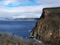
Once you descend onto the peninsula of Cape Hauy, the views to north and south open up quite dramatically. To the south, Cape Pillar makes a fine sight, with The Blade and Tasman Island visible. To the north, the coastline of the Tasman and Forestier Peninsulas, Cape Bernier, Maria Island and Freycinet are visible. On a clear day you may be able to see further than that. The track emerges at the end onto a small rock platform with a sheer 100m+ drop into the sea. Great care is required (especially if here with children), but this is the best spot for stopping and taking in the views and having lunch. Cape Hauy is home to the Candlestick and Totem Pole, both of great interest to climbers. They make spectacular viewing.


The Candlestick from the end of Cape Hauy - 11th August 2008
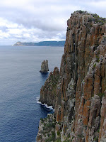
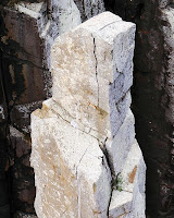
The Candlestick stands next to the end of the Cape clearly visible just next to the lunch spot, and behind it are The Lanterns. The Candlestick is a very tall and thin sea stack, separated from the Cape and the Lanterns by the sea. Lots of information here about climbing these things. As their guide says, the crux of the climb up the Candlestick is the SWIM! You can scramble down the less steep side of the Cape towards the sea, and actually you can get within a few metres of the sea if you keep going. This requires great care in places, and of course you have to climb back up the 100m of height. It does however afford better views of the Candlestick and Totem Pole, and these start only a short way down. My perambulations yesterday had to be curtailed because I took a sidetrip to the Tesselated Pavement on the drive in and left myself rather short of time.


The top of the Totem Pole from Cape Hauy - 11th August 2008
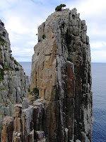
Next to the Candlestick stands the Totem Pole. The climbing guide says this about the Totem Pole: "It is over sixty metres tall, but only about four metres wide at the base. It sways in the wind and shudders with the crash of every wave." Go here for some more dramatic photos of the Totem Pole.


Cape Pillar from the Monument Lookout - 11th August 2008
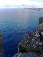
A final detour on the return is well worthwhile to the Monument Lookout. This stands on top of a vertical 150m drop to the sea, and requires great care, as the rocks are rounded and sloping, with good sized cracks between them. Views from here are to the rock stacks off Cape Hauy and Cape Pillar, and in fact very dramatically straight downwards to the surface of the sea. Great place to sit on a nice day.


View Larger Map

Thursday 7 August 2008

Big job ahead for the Huon Valley Council

Erica lusitanica, Spanish Heath, Arve Rd, Southern Tasmania - 17th July 2008Now that I know what I'm looking for I can see that the Erica lusitanica infestation on the Arve Road actually extends for about half a kilometre along the roadside. I think this would be quite a job to remove, and I suspect it won't get a look-in, being a "low-priority" weed.

New view from the Hartz Mountains

Newood timber processing site visible from Hartz Peak - 4th August 2008I know we have to process the wood we harvest as much as possible before we export it, but do we have to build factories to do it where they can be seen from the most accessible summit in the World Heritage Area? We try to encourage tourists to come here, then we stick a new factory on the edge of the WHA where its buildings and especially its smoke emissions are visible from the Hartz Mountains. Bonus! This is Newood, formerly Southwood (note the url, they changed the name because of the original bad publicity. The website seems to be a little out of date), built near the Huon River to process timber from the nearby forests in various ways. It's supposed to have a wood-burning power plant eventually, I bet that'll make it even more attractive. As it is, it stands out very clearly against the backdrop of forests.