Getting to Maria Island
 The ferry currently leaves from near the visitor centre at the Triabunna wharf. Check their website for sailing times. The trips I had recently were fairly rough, although neither was as visually worrying as one the family had a few years ago in a very strong westerly. The boat looks large at the wharf, but does seem smaller amongst the swells. Nonetheless, the blokes running it are very good, and the boat actually handles the sea very well. On days when you can see clearly, there are often dolphins to be seen. On arrival on the island, the rangers will be in attendance at the old Commissariat Store on the seafront to take your money for camping or national park passes. Before heading over right now, it might be worth checking whether your intended activity is possible. Very heavy rain has damaged bridges and roads, and quite massively flooded the campground. There was mention in the press that there would be difficulties with the drinking water supply over summer.
Day 1 - Darlington to Encampment Cove
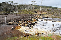 The walk south from Darlington is relatively straightforward. The 4WD track heads up and over the headland to the south, then down to Hopground Beach, where the Painted Cliffs are located. On my trip the creek there was in flood and pouring across 50 metres of road, with a large mat of brush and timber damming it. The latest heavy rain has apparently washed the bridge away, so a short wade may be required. This creek is not normally very large, so it shouldn’t be a problem. From here the track climbs and falls, in and out around the coast. You should see wombats grazing, and there are good views in many places. Frenchs Farm is perhaps two to three hours, depending on what you stop to look at. Camping is possible at Frenchs Farm, and when it isn’t busy, you can probably get away with staying inside the farmhouse. This is not preferred by the rangers, so be prepared to get turfed out. The camping there is good, and there is a toilet. You can also cycle most of these tracks, as two blokes I met at Frenchs Farm had done.
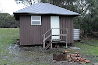 Encampment Cove is another half hour (or less) beyond Frenchs, and the track is clearly signed near the farm. Here you will find a small hut, with “bunks” for about four, and a good bench along the wall for cooking on. On my trip I had this to myself for the three nights I was there. There is also apparently good camping here, however the campground was largely under water during my stay, so I can’t vouch for it completely.
 The location is delightful, with camping within a few steps of the gentle waters of Chinamans Bay. There is a pit toilet here. The shore is mainly rocky, and apparently you can catch fish here – I didn’t, despite a lot of attempts. The sunrise is worth getting up for on clear mornings. There is also the remains of a stone convict-built jetty to add historical interest.
Day 2 - Haunted Bay
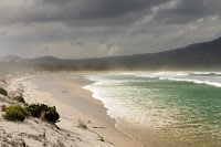 Haunted Bay lies on the southern coast of South Maria. Walking from Encampment Cove it took me about two hours. From Frenchs Farm you take the track south, first walking along the isthmus between Reidle Bay and Shoal Bay. Both bays can be visited easily along several tracks or by picking your way through the scrub. Reidle Bay in particular is worth a visit, and is a good wild ocean beach. The waves here were quite impressive, and on the days I visited were sweeping right up to and even across the low dunes behind the beach. It was interesting to watch the huge mass of water, having swept up and along the dunes, and clearly coloured by the sand it had picked up, smash its way back out to sea through the following waves. There was no doubt that walking along this beach could result in being picked up along with the sand and swept out into the bay.
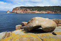 From the south end of the isthmus, the Haunted Bay Track forks left, and heads quite gently uphill and across the south island, before descending very steeply. Haunted Bay is a rugged granite cove, and would be very impressive in rough weather. The waves were quite gentle while I was there. At the end, the track emerges on the rocks, and you can pick your way down sloping granite to the water’s edge. The resident sea eagle checked me out at some length as I arrived, and my attempts to photograph him reminded me why bird photographers spend so much on big expensive lenses. A seal came to visit while I was fishing here (catch: nil), and unfortunately I had left the camera safely out of the way about ten metres higher up. This was a good place to sit and eat lunch, and I’d like to return in wilder weather sometime. I considered returning by walking along the shore of Shoal Bay, however the sand was very soggy, and I used the track instead.
Day 3 - Point Lesueur and Robeys Farm
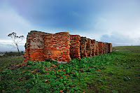 Just north of Encampment Cove, and accessible by a direct track from the campground, is Point Leseuer. This was a secondary convict station in earlier times, and the convict cells remain standing on the windswept hill. There are a variety of interesting features to be seen and explored. It was very windy when I was there, and the rain was coming horizontally. I’ll have to return when the weather is more conducive to ambling about and exploring. I retreated to the more sheltered Encampment Cove to set off for Robeys Farm.
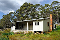 Robeys Farm was farmed until 1965, and lies on the western side of South Maria. Walking south across the isthmus, the track forks right. After crossing the delightfully named Stinking Creek, the track climbs a little and then descends to Robeys Shore. After a short walk uphill the track emerges in a clearing with a tidy and solid weatherboard farmhouse, domestic flowers blooming with somewhat unkempt abandon, and agricultural equipment and machinery scattered about. The farmhouse has had quite a lot of restoration work undertaken in cooperation between the Hobart Walking Club and the National Parks and Wildlife Service, although it is not clear that this is continuing now. Inside the stove and some furniture remains. On the verandah are arranged displays of items obviously left behind, and on the wall inside is the story of Robey. A sign tells you not to camp there, but I think a small group could stay inside if they were careful to leave the place as they found it.
Day 4 - Mount Maria
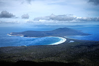 I returned to Darlington on Day 4, via the Inland Track and Mount Maria. This track heads inland about 1.5 km north of Frenchs Farm. It undulates and winds over and around the southwestern foothills of Mount Maria. The climbs and falls are much more significant than on the coast, however the highest point is only about 150m, and it makes for a different return trip. It was very wet underfoot when I was there, but I assume it is normally quite dry and dusty. The side track to Mount Maria is reached where the track climbs up from Hpground Beach. This heads south east up a long ridge, gradually becoming steeper. There is a boulder field to cross and climb, and then the last bit is quite steep with some easy boulder scrambling. The view from the 711m summit is worth the climb, and provides a grandstand view of the various walking areas on Maria Island.
No comments:
Post a Comment